Hurricane Helene Brings Flooding to Georgia and Western Carolinas
Links to South Atlantic Rainfall Maps and U.S. Drought Map
Links to South Atlantic Rainfall Maps and U.S. Drought Map
South Atlantic Water Science Center (SAWSC)
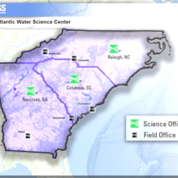
Welcome to USGS South Atlantic Water Science Center's (SAWSC) Website. We offer water information for Georgia, North Carolina, and South Carolina.
News
USGS experts responding simultaneously to two major natural hazards
USGS experts responding simultaneously to two major natural hazards
Hurricane Helene Weakens to Tropical Storm, Brings Flooding to Georgia and Western Carolinas
Hurricane Helene Weakens to Tropical Storm, Brings Flooding to Georgia and Western Carolinas
USGS crews in Florida, Georgia and the Carolinas measuring floodwaters and deploying additional gauges
USGS crews in Florida, Georgia and the Carolinas measuring floodwaters and deploying additional gauges
Publications
Public, bottled, and private drinking water: Shared contaminant-mixture exposures and effects challenge
BACKGROUND: Humans are primary drivers of environmental contaminant exposures worldwide, including in drinking-water (DW). In the United States (US), point-of-use DW (POU DW) is supplied via private tapwater (TW, predominantly private wells), public-supply TW, and bottled water (BW). Differences in management, monitoring, and messaging and lack of directly intercomparable exposure data...
Assessment of fresh groundwater discharge and saline surface-water intrusion at Operable Unit 2, North Chevalier Field Disposal Area (Site 11), Naval Air Station Pensacola, Florida, 2018–22
Site 11 is a former landfill at North Chevalier Field Disposal Area in Operable Unit 2 at Naval Air Station Pensacola, in northwest Florida. Site 11 is adjacent to Bayou Grande, a shallow, tidally influenced, saline estuary of the Pensacola Bay watershed. Federal and Florida regulators have expressed concern that contaminants detected in groundwater beneath the inland parts of Site 11...
Groundwater quality and groundwater levels in Dougherty County, Georgia, April 2020 through January 2023
The Upper Floridan aquifer is the uppermost reliable groundwater source in southwest Georgia. The aquifer lies on top of the Claiborne, Clayton, and Cretaceous aquifers, all of which exhibited water-level declines in the 1960s and 1970s. The U.S. Geological Survey has been working cooperatively with Albany Utilities to monitor groundwater quality and availability in these aquifers since...
Science
Leadership of the South Atlantic Water Science Center
Leadership of the South Atlantic Water Science Center
Groundwater Monitoring Program for the Brunswick-Glynn County Area, Georgia
In the Brunswick, Georgia area, saltwater has contaminated the Upper Floridan aquifer for nearly 50 years. Saltwater contamination has constrained further development of the Upper Floridan aquifer in the Brunswick area, which has stimulated interest in the development of alternative sources of water supply, primarily from the shallower surficial and Brunswick aquifer systems. USGS is working...
Raleigh Bank Erosion Project
The City of Raleigh partnered with the U.S. Geological Survey (USGS) to assist in assessing streambank erosion hotspots along the City of Raleigh’s stream network to support the City’s efforts of prioritizing future stream mitigation projects. Streambank erosion potential will be assessed using remotely sensed light detection and ranging (lidar) data, field assessments of streambank conditions...


